
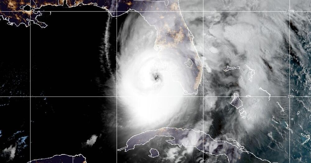


Hurricane Ian was a slow moving, wobbly mega-storm that dangerously intensified as it approached Florida’s gulf coast, complicating landfall and storm surge projections as well as when and where to evacuate.
The Category 4 storm, which brought apocalyptic flooding and damage locally, has raised questions about the reliability of hurricane forecasting, the timing of evacuations orders and the potential impacts of climate change — via higher sea levels and warmer waters — on Ian and future storms.
“One of the challenges was that the storm had a lot of wobble in it,” said Richard Rood, a professor of climate and space sciences and engineering at the University of Michigan.
Those wobbles made it harder to determine where Ian would land and which areas would get hit hardest on the south and east side of Hurricane Ian’s 60-mile-wide eye.
Rood said Ian’s slow movements and warmer waters in the Gulf of Mexico helped intensify the storm (including its winds) as it approached and then slammed into the southwest Florida coast.
Waters in the Gulf of Mexico are as much as 2.7 degree Fahrenheit warmer than contemporary averages between 1981 and 2010, according to Yale University’s School of the Environment.
“The sea level is higher so the storm surge was larger,” Rood said.
Those types of climate change effects could be a precursor to more intense storms with bigger and more dangerous storm surges and flooding in the future.
“These storms are telling a story of what’s going to be happening in the future,” Rood said.
The storm has resulted in more than 100 deaths after hitting near Punta Gorda and Fort Myers rather than the earlier projections that focused on a more direct hit on the Tampa-St. Petersburg area (150 miles north) or Cedar Key (280 miles north).
Several homes in the Holiday Park neighborhood were destroyed by Hurricane Ian. Resident Bob Menchaca tells his story.
Ian’s damages could total as much as $70 billion – the most expensive in the state since Hurricane Andrew in 1992, according to research firm CoreLogic.
“This is the costliest Florida storm since Hurricane Andrew made landfall in 1992 and a record number of homes and properties were lost due to Hurricane Ian’s intense and destructive characteristics,” said Tom Larsen, associate vice president for hazard and risk management at CoreLogic, in an early assessment of the storm’s destruction.
“Hurricane Ian will forever change the real estate industry and city infrastructure. Insurers will go into bankruptcy, homeowners will be forced into delinquency and insurance will become less accessible in regions like Florida,” Larsen’s foreboding financial price tag analysis continued.
Red cones and black lines
The monster storm decimated coastal areas of Lee and Charlotte counties — including well-developed barrier islands with expensive real estate such as Sanibel Island — and brought flooding and wind damage to interior areas, as far as Orlando, Volusia County and St. Augustine.
Dan Kottlowski, lead hurricane forecaster and senior meteorologist with AccuWeather, said projection cones for Ian’s trajectory were pretty accurate.
The problem with hurricane modeling and forecasts, including Ian, can be how information from the U.S government’s National Hurricane Center and other forecasters is deciphered and acted upon by local officials and the general public.
“As a result people get confused,” the AccuWeather hurricane expert said. “A lot of confusion.”
Kottolowski said the federal center publishes cones showing a consensus path of hurricanes and tropical storms based on various models. There is also a center black line in the center of the projection cone that can become the focal point of where storms like Ian might land.
“The problem is I saw some local officials in southwest Florida areas, somehow they were looking at the line,” Kottolowski said. “They shouldn’t have been looking at the line. They should have been looking at the cone.”
That has raised questions about when evacuation orders were put in place, particularly in Lee County.
Lee County, which felt the brunt of the storm’s landfall Sept. 28, issued evacuation orders on Sept. 27.
That was after other counties along the coast also threatened by Ian which intensified into a Category 4 hurricane with peak winds of 155 miles per hour.
Lee County has been accounting for the majority of Ian’s deaths, according to the Florida Medical Examiners Commission. The county reported 53 deaths from the storm along with more than 1,000 rescue missions, Lee County Sheriff Carmine Marceno said Friday. “I wish it was zero,” Marceno said of the storm’s fatalities during a media briefing.
Local and state officials stand by their handling of the storm and emergency and evacuation orders.
“We were not in the cone,” Marceno said during a media briefing Oct. 3 of earlier trajectories of the storm. “These storms are very unpredictable, OK. And people have to listen. You know you live in a place like Florida that is susceptible to hurricanes.”
Marceno said he stands by Lee county officials’ handling of the storm.
“This storm was supposed to go up to the Tampa sheriff who I spoke to hours before it turned and hit us,” said Marceno, who made appearances on ABC’S “Good Morning America” and NBC’s “Today Show” after the storm.
“I am confident in our county manager, our leaders, our governor, all us in law enforcement that we got that message out at the right time,” Marceno said, adding that he would not have changed the county’s approach.
“And mother nature taught us a lesson. It’s unpredictable. But I’m confident, confident in the decisions that were made,” the sheriff said.
‘Abundant and well in advance’
Neighboring Charlotte County began issuing Ian evacuation orders Sept. 26. That was a path mirrored by other localities.
“We took it seriously from the very beginning,” Brian Gleason, communications manager for the Charlotte County Board of Commissioners.
Gleason said there were daily and routine calls with the National Hurricane Center with state officials and local emergency managers throughout the region and state about Ian’s path.
He said information provided to local emergency managers was based on data disseminated publicly.
“Everybody was getting the same information in real time — including the track. They didn’t give out information that wasn’t already public,” Gleason said.
The slow and wobbly nature of the storm created uncertainty as to where it might make landfall and which areas might feel the most damage from the south and east sides of the eye walls.
“We knew that it was wobbling. It was just a matter of how far it wobbled,” Gleason said.
Charlotte County also relies on a private forecaster — Norway-based StormGeo — to supplement its weather information, Gleason said.
“All tropical storms move in an erratic path,” said Gleason of the importance of NHC guidance as well as the private forecasting help.
Sarasota and Manatee counties also issued its first evacuation orders Sept. 26.
But the storm was in local and regional emergency managers’ sights well before that.
“Our Public Safety Department began monitoring this storm — and sharing with about 1,000 local and regional partners information about what would become Ian when it was still Tropical Depression #9 at 6:21 a.m. on September 23,” said Bill Logan, information outreach manager for Manatee County.
Logan said communications included daily calls with state emergency officials, local cohorts, NHC and Florida National Guard.
“Our advisories were abundant and well in advance of the storm,” Logan said.
Florida Gov. Ron DeSantis and the state’s Emergency Management Director Kevin Guthrie said evacuation orders are under the purview of local officials — in particular county emergency managers, county managers, sheriffs and their elected cohorts.
Both DeSantis and Guthrie said they are not going to second guess local decisions related to Ian.
“They made the best decision based on the information they had at the time,” Guthrie said during a media briefing Monday . “I will never second-guess a local emergency manager’s decision to issue an emergency evacuation order.”
‘Tampa, Tampa, Tampa’
In the Tampa area, Pinellas and Hillsborough counties also issued expansive evacuation orders starting Sept. 26.
The Tampa Bay area has not seen a direct hurricane hit since 1921. Ian’s projected severity and high storm surge put a major pre-landfall focus on potential direct hit on a 3.2 million-person metro area that is larger than St. Louis and Denver.
“You were hearing some reports of Tampa, Tampa, Tampa,” said Erik Salna, a meteorologist and associate director for education and outreach for the International Hurricane Research Center and Extreme Events Institute at Florida International University.
That could have taken some focus away from the chances of Ian following a path similar to Hurricane Charley in 2008 through southwest Florida, Salna said.
“That centerline can be misleading,” Salna said of the hurricane’s projected trajectory.
A more Charley-like path was projected earliest by a European hurricane model from the European Centre for Medium-Range Weather Forecasts (ECMWF) which relies more on satellite imagery and fast supercomputers. The Euro model is also included in the U.S. hurricane center’s consensus projections and hurricane cones.
Salna and the other hurricane experts said generally the NHC forecast was accurate within current parameters and state of storm predictions.
“From my point of view, I thought it was quite a good forecast,” said Rood, adding that being off by 125 miles is well within the usual range and margin of error for where hurricanes can land.
The challenge is communicating projected cones, potential impacts on the storm’s trajectory (such as fronts that ended moving Ian’s eye and landfall to southwest Florida) and other uncertainties to the public and emergency managers.
Some of the hurricane graphics — including complex spaghetti overlays showing a myriad of models and projections — can also add to confusion and conceptions about storms, including Ian which saw early projections of hits in the Florida Panhandle, Cedar Key and Tampa Bay.
“It’s a big challenge — trying to look at how these things will all come together. The story can change from day-to-day,” said Salna, whose university is expanding its storm and wind research at its Wall of Wind (WOW) Experimental Facility.
Officials at the National Hurricane Center in Miami declined to comment on projections for Ian and differences between various U.S. and European models.
“We are still gathering and analyzing the data and will provide a full analysis when the Tropical Cyclone Report for Hurricane Ian is completed,” said Maria Torres, communications and public affairs officer and meteorologist for the NHC.
That assessment likely won’t be published until spring of 2023,” Torres said.
A number of government and elected officials in southwest Florida also did not respond to requests for comment or deferred questions about what went right and what went wrong with Ian.
Debbie McDowell, a commissioner with the city of North Port, said it was still early to look at what went right and what needs improvement in relation to Ian.
“Storm paths, projections and computer models mean nothing to Mother Nature; she is anything but predictable. My opinions of what can be improved upon, are premature,” said McDowell, who has been through four hurricanes the past 30 years in Sarasota County. “Like all disasters there are things that were executed with precision and others areas will need to be improved upon. When the time is right, those conversations will take place; just not right now.”
McDowell did laud the work and long hours of municipal staff, contributions of local businesses and community volunteers. “Hurricane Ian doesn’t know how strong North Port is,” she said.
In Florida, mandatory evacuations are not really mandatory. The orders are serious but police are not arresting people for disobeying and staying in their homes.
“We can’t force them to leave their homes. That’s their homes,” Marceno said.
AccuWeather’s Kottolowski said research has shown as much as 20% to 30% of a population can resist evacuation orders. That number could be higher in some communities.
Uncertainty about where hurricanes will land and damage, mobility challenges with older residents, financial limitations among lower-income households, concerns about pets and leaving homes and past storms that ended up bypassing evacuated areas all contribute to some Floridians’ penchant to ride out storms.
Kottolowski said the NHC does not tell local officials what to do in terms of evacuations. He said elected officials can play a role in evacuation decisions and that can create political considerations.
He said local officials who order evacuations run the risk of criticism if storms land elsewhere. “It’s like egg on your face,” he said.
He said warming Gulf waters and other “oceanic heat waves” also need to play a future role in gauging storms as well as preparations for them.
“The intensity of the storms are problematic because water temperatures are so warm,” he said, saying the warming impact can add any additional 10 to 20 MPH to a storm.
Salna said Florida hurricane veterans who have weathered past storms need to realize past experiences will not always be replicated by future storms.
He said Ian was a very fresh and very serious reminder of intensifying storms.
“No one’s been through something like this,” Salna said. “This is a whole different animal here.”
The FIU hurricane expert also said while Florida’s evacuation orders are not mandated by the government or police, residents should make their own informed decisions.
“Do you wait for an evacuation order — or do you think for yourself,” he said.